
- CONTINENTAL DRIFT
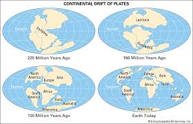
Through out most of history people believed that the continents were permanent and unmoving. - Alfred Wegener in 1910 was one of the first geologist to suggest the continents used to be joined together in one Super-continent he called Pangaea, meaning “all land”
- Wegener (1910) proposed the hypothesis of continental drift which suggested that the continents were like icebergs of granite floating in a sea of more dense basalt.
 Evidences to support Continental Drift
- Fossils
- Mountains
- Glacial Scars
- Sea floor spreading and rift valley
- Age and type of the rock
- Paleo-Magnetism and Magnetic data
- Paleomagnetism:
British scientists find that magnetic fields recorded in rocks from Europe and North America indicates the rocks were formed in far different locations than their present positions.
Evidences
FOSSILS - One of the first pieces of evidence to support continental drift was the discovery of fossils.
- An ancient freshwater reptile, Mesosaurus, was found in both Africa and South America.
Tropical plant fossils were found in places that they would not normally be able to grow. Fossils of the plant genus Glossopteris occur on all five Gondwana continents.
GLACIERS
Marks left by glaciers on rocks in Africa, India, South America and Australia make no sense — unless these continents were joined and arrayed around the South Pole.
Rock type
People also noticed that similar rocks could be found on opposite sides of the Atlantic
Sea floor Spreading
- The ocean floors are spreading away from mid-oceanic ridges, indicating that the ocean floor is moving.
The rocks near the mid-ocean ridge are much newer than the rocks that are farther away.
It was concluded that the seafloor was spreading along the mid-oceanic ridge.Later studies showed that the rocks in the seafloor had alternating bands of magnetism that correlated with reversals in Earth’s Magnetic Field.
- Weakness of Continental Drift Theory
Wegener had concentrated on developing evidence that continents had drifted (1910-30), not on how they moved.
In 1930-60 the theory were supported by few geologists. Modern evidence indicates that the continents were together much as Wegener had portrayed them in his map of Pangaea.
Most geologists recognize the importance of Wegener’s contributions after the Plate Tectonic Theory which provides a single, unifying framework that explains: - Earthquakes,
- Volcanic eruptions,
- Moving continents,
- And many other geological events
Earthquakes
Earthquake is a sudden motion or rambling of the Earth caused by the abrupt release of energy that is stored in rocks.
Earthquakes are caused by the motion of Earth’s Crust. Plates grind or slip past each other causing tension
Note:
Before the plate tectonics theory, geologists recognized that earthquakes occur frequently in some regions and infrequently in others, but they did not understand why.
Modern geologists know that most earthquakes occur along plate boundaries, where huge tectonic plates diverge, converge, or slip past one another
Seismology is the study of earthquakes and the nature of the Earth’s interior based on evidence from seismic waves.
Waves that travel through rock are called seismic waves an earthquake produces several different types of seismic waves
Body wave’s travel through the Earth’s interior, they radiate from focus.
Focus is an initial rupture point of an earthquake. Most foci occur along plate boundaries, also called faults
EPICENTER – location on the earth where the earthquake begins. The point on the Earth’s surface directly above the focus
Body waves carry some of the energy from the focus to the surface.
Surface waves then radiate from the epicenter along the Earth’s surface and undulate across the ground.
Earthquake focus and epicenter the focus is the zone within Earth where the initial displacement occurs. The epicenter is the surface location directly above the focus.
Seismic Waves
Two types of seismic waves radiate out from the focus of an earthquake
Body waves are divided into two types;primary (P) waves and secondary (S) waves.
Primary waves move particles back and forth like sound waves.
Secondary waves move particles up and down like ocean waves
On the surface these two waves join to give the ground an elliptical motion.
Earthquakes cause massive damage to man-made and natural structures.
P waves are “push–pull” waves—they momentarily push (squeeze) and pull (stretch) rocks in the direction the wave is traveling.
S waves “shake” the particles at right angles to their direction of travel.
P waves, which temporarily change the volume of intervening material by alternately squeezing and stretching it while S waves change the shape of the material that transmits them.
As surface waves travel along the ground, they cause the ground and anything resting upon it to move,
Seismic waves don’t just locate the focus or epicenter. They can also be used to map Earth’s interior because only primary waves are able to travel through molten rock. They can show us the location of magma chambers beneath volcanoes.
Measuring Earth Quake
Earthquakes can be measured using a seismometer, which traces the effect of the seismic waves on a rotating drum.
These tracings can be used to measure the energy or strength of the earthquake which is described with the Richter scale.
RICHTER SCALE – uses information from seismographs to determine relative strength of an earthquake
Richter scale
Is a log base scale.
A 2.00 earthquake is 10 times stronger than a 1.00 earthquake.
Under 4.00 is considered to be minor and over 6.00 is considered to be strong.
Weaker earthquakes are very common while strong earthquakes are very rare.
The strongest recorded earthquake was a 9.5 in Chile in 1960.
TSUNAMI
A giant wave in the ocean caused by an earthquake
When an earthquake strikes under or near water the waves it releases can travel through the water generating an enormous wave.
These waves can cause lots of damage when they hit shorelines.
Dec 26, 2004 an earthquake of the coast of Sumatra generated a tsunami that had a death toll of 230,000 people and traveled across the entire Indian Ocean Most tsunami are caused by the vertical displacement of a slab of Sea floor along a fault on the ocean floor or less often by a large submarine landslide triggered by an earthquake
As waves slow in shallow water, they grow in height until they collapse and rush onto shore with tremendous force.
Earthquake and Plate boundary
Earthquakes are common at all three types of plate boundaries.
The San Andreas Fault zone is an example of a transform plate boundary, where two plates slide past one another.
Subduction zone earthquakes occur when the subducting plate slips suddenly.
Earthquakes occur at divergent plate boundaries as blocks of lithosphere along the fault drop downward.
Earthquakes occur in plate interiors along old faults or where sediment depresses the lithosphere.
VOLCANIC LAND FORMS
- Exclusive landforms
Exclusive land forms are formed from materials thrown out during volcanic activities - A Conical Vent
A narrow cylindrical vent through which magma flows out violently; conical vents are common in composite or strato-volcano volcanism - A Fissure Vent
A narrow linear volcanic vent which lava erupts, usually without any explosive activity - Mid – Ocean Ridges
These volcanoes occur in the oceanic areas, they are more than 70000 km long that stretches through all the ocean basins. Lava is basaltic in nature (less silica and hence less viscous) - Composite Volcano
They are conical or central type volcanic land forms along with andesitic lava and pyroclastic material accumulates in the vicinity of the vent openings leading to formation of layer and this makes the mounts appear as composite volcanoes. - Shield Volcano
These volcanoes are mostly made up of basalt which is very fluid when erupted, they are gently sloping mountain. - Cinder Cone
A small volcano of loose pyroclastic fragments such as volcanic clinkers, cinders, volcanic ash or scoria that has been built around a volcanic vent, a cinder cone forms when large amount of gas accumulate in rising magma - Caldera
After eruption of magma has ceased the crater frequently widening up and turns into a lake at later time - Lava Dome
Also called volcanic dome form in craters of volcanoes after a major eruption, highly viscous lava with little gas content oozes out of the volcano’s vent like toothpaste out of a tube. The pasty lava is too thick to flow and it solidifies on top of the vent form rounded steep- sided mound. - Lava Plateau
Formed when lava pours fourth through fissures or long narrow cracks in the ground instead of through a central vent in a volcano, this thin lava tends to spread out rapidly and widely flooding the surrounding landscape.
Intrusive landforms
a). Batholiths
Large rock masses formed due to cooling down and solidification of hot magma inside the earth. They appear on the earth only after the denudation processes remove the overlying materials, they are granitic.
b). Laccoliths
Large dome-shaped intrusive bodies connected by pipe like conduct from below, are basically intrusive counterparts of an exposed dome like batholiths.
c). Lapolith
Formed when lava moves upward and a portion of the same tend to move horizontal direction when it finds weak plane, and develops into a saucer shape or concave
d). Phacolith
A wavy mass of intrusive rocks found at the base of synclines or at the top of anticline in folded igneous rock. Wavy materials have a definite conduit to source beneath in the form of magma chambers.
e). Dykes
Formed when the lava makes its way through cracks and the fissures developed in the land then it solidifies almost perpendicular to the ground.
f). Sills
These are solidified horizontal lava layers inside the earth, near horizontal bodies of the intrusive igneous rocks are called sill or sheet depending on the thickness of the materials. The thinner ones are called sheets while the thick horizontal deposits are called sills.
